-
Wählen Sie die Sprache der Website
-
 Deutsch
DE
Deutsch
DE
-
 English
EN
English
EN
-
 Français
FR
Français
FR
-
 Español
ES
Español
ES
-
 Italiano
IT
Italiano
IT
-
 Polski
PL
Polski
PL
-
 Português
PT
Português
PT
-
Land, in das versendet werden soll

-
Wählen Sie die Sprache der Website
-
Deutsch
DE
-
English
EN
-
Français
FR
-
Español
ES
-
Italiano
IT
-
Polski
PL
-
Português
PT
-
Land, in das versendet werden soll
-
Wählen Sie die Sprache der Website
-
Deutsch
DE
-
English
EN
-
Français
FR
-
Español
ES
-
Italiano
IT
-
Polski
PL
-
Português
PT
-
Land, in das versendet werden soll
-
Menue

-
Ränge

-
Brettspiele

-
Rollenspiel

-
Partyspiele

-
CG

-
Zubehör

-
Lego

-
Buecher

-
Comics


Herausgeber: Historic One
Cry Havoc Map The Welsh Castle

uplay.it Preis
Einzelhandelspreis
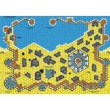
Herausgeber: Historic One
Cry Havoc Map The Fortified Village
uplay.it Preis
Einzelhandelspreis
Herausgeber: Historic One
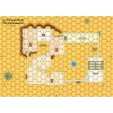
Cry Havoc Map The Caravanserai
uplay.it Preis
Einzelhandelspreis
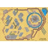
Herausgeber: Historic One
Cry Havoc Map The Saxon Harbour
uplay.it Preis
Einzelhandelspreis
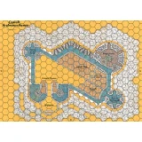
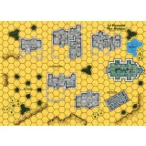
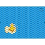
Herausgeber: Historic One
Cry Havoc Map The Welsh Castle
Map showing a castle with the architecture typical of the fortresses King Edward I of England built at the beginning of the 14th century to contro...
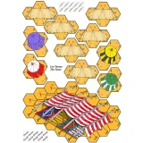
Herausgeber: Historic One
Cry Havoc Map The Fortified Village
Double map representing a circular castle and its village defended by a wooden palisade. The plan is inspired by the castle of Avalon in the Daup...
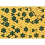
Herausgeber: Historic One
Cry Havoc Map The Hamlet
Map representing a village grouped around its church. The map meets the Cry Havoc standard, is printed in high definition (300 dpi) and on a strong...
Herausgeber: Historic One
Cry Havoc Map The Caravanserai
The map displays a courtyard surrounded by stables and an inn. A covered passage provides access to a small medina located higher up. The map meets...
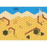
Herausgeber: Historic One
Cry Havoc Map The Beach
Map showing a coast with a beach protected by embankments. The map meets the Cry Havoc standard, is printed in high definition (300 dpi) and on a s...
Herausgeber: Historic One
Cry Havoc Map The Cove
Map showing a coast with a cove dominated by a watchtower and some dwellings. The map meets the Cry Havoc standard, is printed in high definition...
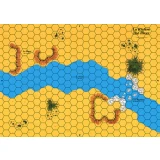
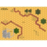
Herausgeber: Historic One
Cry Havoc Map The River
Map showing flat land cut through by a river that crosses at a ford. The map meets the Cry Havoc standard, is printed in high definition (300 dpi)...
Herausgeber: Historic One
Cry Havoc Map The Islet
Map of an ocean with a small island. The map meets the Cry Havoc standard, is printed in high definition (300 dpi) and on a strong varnished cardb...
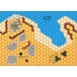
Herausgeber: Historic One
Cry Havoc Map The Sheephold
Map representing a small pass guarded by a sheepfold. The map meets the Cry Havoc standard, is printed in high definition (300 dpi) and on a stron...
Herausgeber: Historic One
Cry Havoc Map The Woods
Map depicting a small forest. The map meets the Cry Havoc standard, is printed in high definition (300 dpi) and on a strong varnished cardboard si...
Herausgeber: Historic One
Cry Havoc Map The Saxon Harbour
The FORTIFIED HARBOR is made up of 4 maps designed by Jean-Michel Clément. The port itself occupies 2 maps, with its warehouse and its pier, and it...
Herausgeber: Historic One
Cry Havoc Overlay The Tents
Overlays printed on A4 heavy paper featuring several tents and a larger one used by emirs. A component of the AGER SANGUINIS boxed set.