-
Elige el idioma del sitio web
-
 Deutsch
DE
Deutsch
DE
-
 English
EN
English
EN
-
 Français
FR
Français
FR
-
 Español
ES
Español
ES
-
 Italiano
IT
Italiano
IT
-
 Polski
PL
Polski
PL
-
 Português
PT
Português
PT
-
País al que enviar

-
Elige el idioma del sitio web
-
Deutsch
DE
-
English
EN
-
Français
FR
-
Español
ES
-
Italiano
IT
-
Polski
PL
-
Português
PT
-
País al que enviar
-
Elige el idioma del sitio web
-
Deutsch
DE
-
English
EN
-
Français
FR
-
Español
ES
-
Italiano
IT
-
Polski
PL
-
Português
PT
-
País al que enviar
-
Menú

-
Rangos

-
juego de mesa

-
juego de rol

-
Party

-
CG

-
Accesorios

-
Lego

-
Reservar

-
C?mics


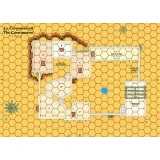
Editor: Historic One
Cry Havoc Map The Fortified Village

uplay.it Precio
Precio minorista
Editor: Historic One
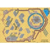
Cry Havoc Map The Welsh Castle
Mapa que muestra un castillo con la arquitectura típica de las fortalezas que construyó el rey Eduardo I de Inglaterra a principios del siglo XIV para...
Editor: Historic One
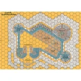
Cry Havoc Map The Fortified Village
Double map representing a circular castle and its village defended by a wooden palisade. The plan is inspired by the castle of Avalon in the Daup...
Editor: Historic One
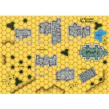
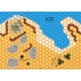
Cry Havoc Map The Hamlet
Map representing a village grouped around its church. The map meets the Cry Havoc standard, is printed in high definition (300 dpi) and on a strong...
Editor: Historic One
Cry Havoc Map The Caravanserai
The map displays a courtyard surrounded by stables and an inn. A covered passage provides access to a small medina located higher up. The map meets...
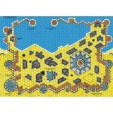
Editor: Historic One
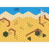
Cry Havoc Map The Beach
Mapa que muestra una costa con una playa protegida por terraplenes. El mapa cumple con el estándar Cry Havoc, está impreso en alta definición (300 dpi...
Editor: Historic One
Cry Havoc Map The Cove
Map showing a coast with a cove dominated by a watchtower and some dwellings. The map meets the Cry Havoc standard, is printed in high definition...
Editor: Historic One
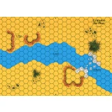
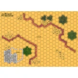
Cry Havoc Map The River
Map showing flat land cut through by a river that crosses at a ford. The map meets the Cry Havoc standard, is printed in high definition (300 dpi)...
Editor: Historic One
Cry Havoc Map The Islet
Map of an ocean with a small island. The map meets the Cry Havoc standard, is printed in high definition (300 dpi) and on a strong varnished cardb...
Editor: Historic One
Cry Havoc Map The Sheephold
Map representing a small pass guarded by a sheepfold. The map meets the Cry Havoc standard, is printed in high definition (300 dpi) and on a stron...
Editor: Historic One
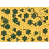
Cry Havoc Map The Woods
Map depicting a small forest. The map meets the Cry Havoc standard, is printed in high definition (300 dpi) and on a strong varnished cardboard si...
Editor: Historic One
Cry Havoc Map The Saxon Harbour
El PUERTO FORTIFICADO está compuesto por 4 mapas diseñados por Jean-Michel Clément. El puerto en sí ocupa 2 mapas, con su almacén y su muelle, y está...
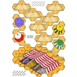
Editor: Historic One
Cry Havoc Overlay The Tents
Overlays printed on A4 heavy paper featuring several tents and a larger one used by emirs. A component of the AGER SANGUINIS boxed set.